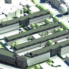
Coalville, Leicestershire, 18 September 2012 – 3D models created from high resolution aerial photography are supporting the pioneering use of Building Information Modelling (BIM) on regeneration and construction projects across London. Created by Bluesky and supplied to David Miller Architects the 3D models accurately place the projects in their real world multi dimension context. This provides a base for the integration of other project critical data and allows David Miller Architects to effectively manage the project and communicate with stakeholders. BIM is designed to drive cost and carbon reductions and will be required on public sector projects by 2016
“The need for speedy, accurate and affordable 3D information led us to Bluesky,” commented David McMahon, Senior Architect at David Miller Architects. “For initial conception and feasibility stage proposals, where a full scale survey of the site is neither practicable nor cost effective, but 3D information is desired, being able to obtain this level of information from Bluesky is the perfect solution.”
The 3D models created by Bluesky on behalf of David Miller Architects have included an area of St John’s Wood, Westminster around a new school building site, an area around Elgin Avenue, also in Westminster, for community homes estate regeneration and an area around Paris Gardens, Southwark for new build student housing. The 3D data from Bluesky is integrated into the company’s 3D BIM software to help determine the extents and possible constraints of the site. Using the BIM software other information, such as ‘right to light’, can also be integrated. This allows for the limitations of development to be identified and outlined and facilitates the production of imagery that can be presented to stakeholders.
“Outsourcing this critical part of the process allows us to focus on the design, development and validation of a scheme, rather than having to concentrate our initial efforts on modelling the surrounding context, a process which we have historically struggled to carry out to the degrees of accuracy afforded to us by Bluesky,” concluded David McMahon.
Bluesky’s bespoke building models are created from the most up to date, high-resolution, stereo aerial photography. They are created to the client’s specification and can include road detail and an underlying Digital Terrain Map (DTM) to place the urban representation in its true world context. The standard Bluesky 3D city model can also be enhanced with the addition of vertical, oblique or ground photography to deliver additional detail and real world visual impact.