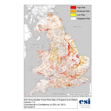
The UK’s leading independent scientific environmental consultancy specialising in water, land and sustainable development has addressed groundwater flooding issues in England and Wales by launching an authoritative Groundwater Flood Risk Map.
ESI is recognised as the leading independent provider of water resource services through one of the largest and most technically capable groundwater teams in the UK.
Its team of modellers has overcome constraints on previous work by developing novel algorithms and using calibrated risk predictions to achieve an authoritative national map of groundwater flood risk.
“Until now, and compared to other causes of flooding, groundwater flooding mechanisms and the prevalence of flooding caused by groundwater have been poorly defined,” explained Mark Fermor, experienced hydrogeologist and Managing Director at ESI.
“Groundwater flooding represents one of the natural hazards faced in the UK and mapping of groundwater flood risk areas provides an important support to land use planning and in the assessment of climate change impacts. However, previous approaches have suggested problems are far more widespread than they really are, and ESI’s work has helped to show that the issues are actually quite localised.”
Groundwater flooding occurs when sub-surface water emerges from the ground following persistent rainfall that recharges aquifers1, such as limestones or sandstones, until they are full; or as a result of high river levels or tides driving water through near-surface deposits. These mechanisms are represented in ESI’s Groundwater Flood Risk Map.
Mark added: “The new Groundwater Flood Risk Model emphasises that the areas at risk from groundwater flooding are considerably less than previously flagged by others – a finding that will potentially have a major impact on those with responsibility for land management and development, as well as those currently living and working in seemingly ‘at risk’ areas. However, groundwater flooding does represent a significant hazard in England and Wales, and groundwater conditions can also exacerbate surface flooding, so we wanted to publish this map to help users focus on where appropriate precautions should be taken. As with many environmental hazards, most sites may not suffer problems, but if you do not have a reliable map then the issues keep coming back up the list of priorities until you do”
Based on innovative application of authoritative science and quality assured methods, the production of datasets and map output from ESI’s new model provide an improved assessment of groundwater flood risk. As a result, preliminary assessment of risk can now be made available at low cost at all locations on mainland Britain.
The ESI Groundwater Flood Risk Model incorporates algorithms combining the best available data on groundwater systems and records of previous groundwater flood events to produce the most accurate map available representing flood risk on a national scale.
ESI works alongside a number of local authorities UK-wide on groundwater and flooding issues, in particular with Lead Local Flood Authorities, who have primary responsibility for developing, maintaining and applying a strategy for local flood risk management in their areas and for managing the risk of flooding. To assist in this, ESI is offering local authorities who join its User Group and commit to providing data on incidents and observations that will help ESI further develop its national database on groundwater flooding, the opportunity to obtain a complimentary licence for this unique groundwater flood risk map for use internally and to enable members of the public concerned about groundwater flooding to consult the map at their local Council offices.
Founded in 1996, ESI offers a unique combination of leading edge services in the technically complex and rapidly developing fields of groundwater science and risk assessment. ESI’s technical strength is at the heart of the business. The consultancy team comprises some of the most experienced and talented in the industry, with an average of over ten years experience.
A team of 45 technical specialists represent one of the most important centres of groundwater and land quality knowledge in the UK. Among them there are 9 PhDs, 32 MScs and 7 Chartered Geologists. This unique combination of technical expertise and professional experience gives ESI the ability to tackle the most demanding groundwater, geoenvironmental and sustainable development issues in the industry.